Elevate your local knowledge
Sign up for the iNFOnews newsletter today!
Sign up for the iNFOnews newsletter today!
Selecting your primary region ensures you get the stories that matter to you first.


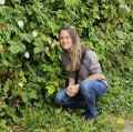
Kamloops outdoor enthusiast Mary Anne Neutelings explored the Enderby Cliffs last week where she photographed a bounty of wildflowers and took in stunning views of the Shuswap and North Okanagan from atop the cliffs.
“It was a warm day and the flowers were amazing, I love wildflowers,” she said. “About five years ago I started identifying more of them using an app on my phone, it’s so cool.”
Neutelings followed the main Tplaqin Trail that winds its way to the summit, emerging from forest cover in several spots where she was able to snap some photos of the views.

“You can see the cliffs from the highway from miles away and I’d heard about them over the years,” she said. “It was time to do it so I went with good friends. At the top we were a metre away from the edge and the view was amazing, you can see the Shuswap River winding down below.”
The cliffs are in Enderby Cliffs Provincial Park located five kilometres northeast of Enderby. The park and trail head can be accessed by turning east onto Cliff Avenue from highway 97 in Enderby and following it as it turns in Mable Lake Road, according to BC Parks.

Take a left hand turn onto Brash Allen Road and at the forks at 1.4 km stay right until reaching a parking lot which is also where the trail begins.
It takes between one-and-a-half to two hours to complete the hike each way and dogs must be kept on a leash.


News from © iNFOnews.ca, . All rights reserved.
This material may not be published, broadcast, rewritten or redistributed.
This site is protected by reCAPTCHA and the Google Privacy Policy and Terms of Service apply.
Want to share your thoughts, add context, or connect with others in your community?
You must be logged in to post a comment.