Elevate your local knowledge
Sign up for the iNFOnews newsletter today!
Sign up for the iNFOnews newsletter today!
Selecting your primary region ensures you get the stories that matter to you first.

UPDATE: 10:12 p.m. July 14 – All weather watches, warnings and statements have ended.
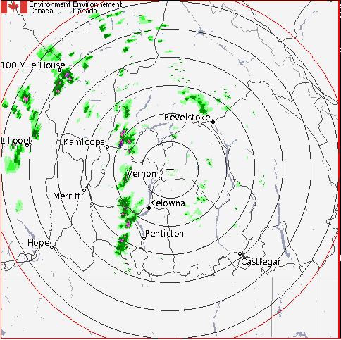
THOMPSON-OKANAGAN – A severe thunderstorm watch remains in effect for the Okanagan, while a warning for the Kamloops area has now been rescinded.
Thursday afternoon, Environment Canada meteorologists were tracking a severe thunderstorm 25 km east of Kamloops along Highway 1 moving northwards, however shortly before 5 p.m. a severe thunderstorm warning for the South Thompson was cancelled.
Vernon, Kelowna and Penticton are still being told to prepare for possible strong wind gusts, hail and localized heavy rain this afternoon and evening, according to a severe thunderstorm watch advisory from Environment Canada.
Meteorologists have been tracking a system coming in from the west that could drop up to 20 mm of rain in some areas.
"As the atmosphere becomes unstable later today, parts of the southern B.C. Interior are likely to receive heavy showers and embedded thunderstorms this afternoon and tonight," Environment Canada says. "Due to the convective nature of these showers, rainfall will be highly variable across these regions."
Environment Canada notes there is risk of flooding and creating dangerous driving conditions as well as specific concerns about thunder and lightning. The office suggests you move indoors in a lightning storm.
Environment Canada issues three types of weather alerts:
Weather statements are considered the least urgent type and just serve to inform the public about unusual conditions.
Advisories are for specific weather events that are less severe but can still significantly impact the public.
Watches are alerts that get issued when weather conditions are favourable for the creation of a storm or severe weather that has the ability to cause safety concerns.
Plan accordingly and come back here for updates.

– This story was updated at 10:15 p.m. to say all warnings were ended
– This story was updated at 4:49 p.m. July 14, 2016 to say the severe thunderstorm warning for Kamloops was cancelled.
– This story was updated at 4:06 p.m. to include the updated thunderstorm warning for Kamloops
– This story was updated at 11:48 a.m. when the thunderstorm watch was issued and again at 4 p.m. July 14, 2016 to say the severe thunderstorm watch was upgraded to a warning in Kamloops
To contact a reporter for this story, email Marshall Jones or call 250-718-2724 or email the editor. You can also submit photos, videos or news tips to the newsroom and be entered to win a monthly prize draw.
We welcome your comments and opinions on our stories but play nice. We won't censor or delete comments unless they contain off-topic statements or links, unnecessary vulgarity, false facts, spam or obviously fake profiles. If you have any concerns about what you see in comments, email the editor in the link above.
News from © iNFOnews.ca, . All rights reserved.
This material may not be published, broadcast, rewritten or redistributed.

This site is protected by reCAPTCHA and the Google Privacy Policy and Terms of Service apply.
Want to share your thoughts, add context, or connect with others in your community?
You must be logged in to post a comment.