Coquihalla Highway reopens after towering flames shut B.C. route for days
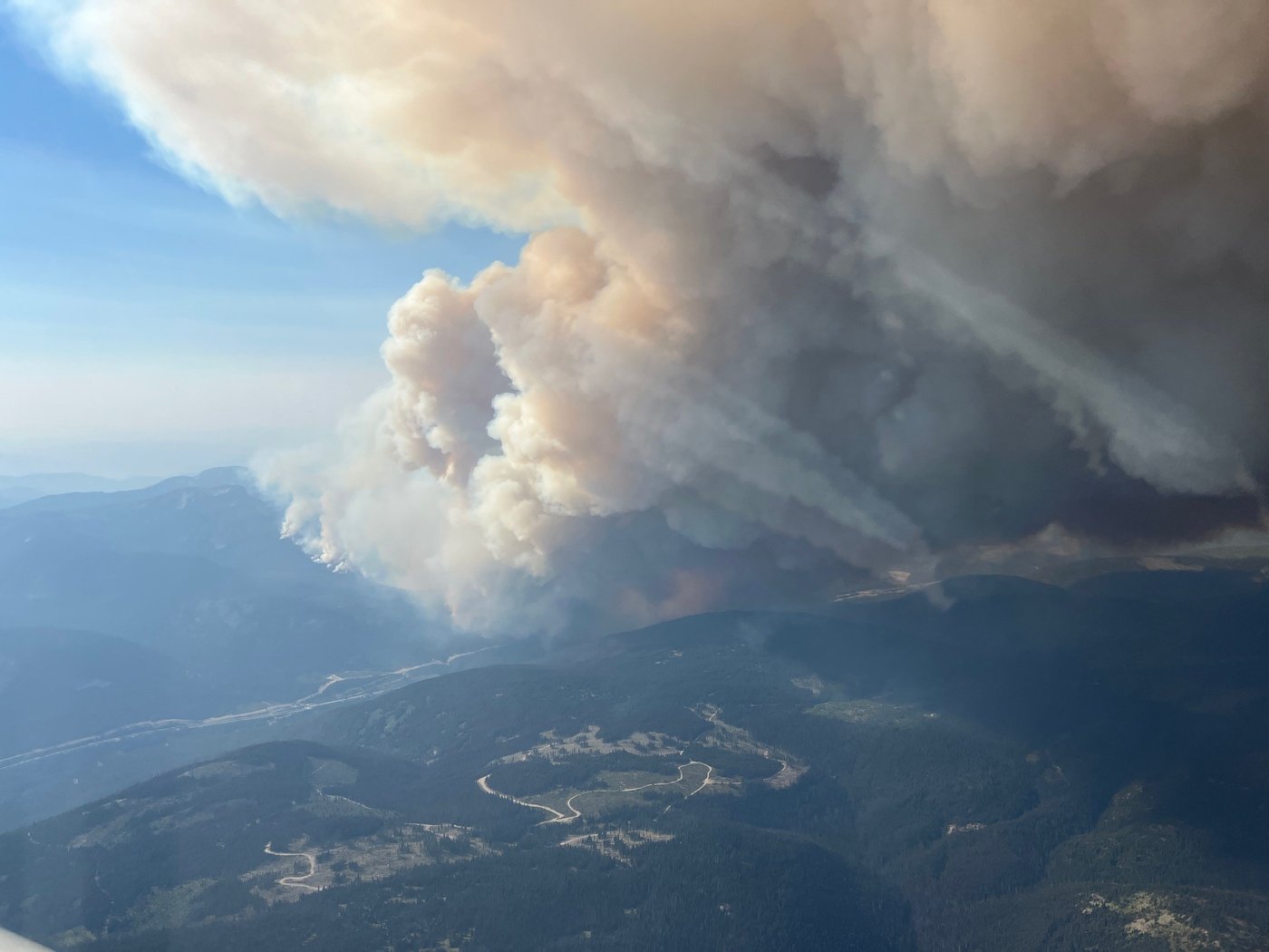
CHILLIWACK — The Coquihalla Highway, a key route to and from British Columbia’s Lower Mainland, has reopened two days after it was jumped by a wind-fuelled wildfire.
The Transportation Ministry says in a statement that the fire is still burning along the highway between Hope and Merritt and drivers can expect the route to close again with little notice.
It says drivers are advised not to stop in the fire zone and that there will be intermittent lane closures as crews assess and repair roadside damage.
The ministry says cellphone coverage has also been affected by the fire with no coverage along some parts of the route, and because the wildlife fences have been burned, there may also be more animals on the road.
The Fraser Valley Regional District declared a state of local emergency because of the blaze, known as the Mine Creek wildfire, and issued evacuation orders for the Coquihalla Lakes Lodge and the Coquihalla Summit Snowmobile Club.
Two other fires have also triggered evacuation orders from the Cariboo Regional District and the Ulkatcho First Nation for areas around Anahim Lake, Nimpo Lake and Charlotte Lake.
The evacuation orders in the Cariboo Regional District have been prompted by the 93-square-kilometre Beef Trail Creek wildfire and the Dusty Lake fire that has grown to around 52 square kilometres.
Evacuees have been told to leave immediately and head east along Highway 20 to Williams Lake where they can register and get help at the Cariboo Memorial Recreation Complex.
The BC Wildfire Service says an incoming weather system will bring little rain but an increased chance of lightning and gusty winds, raising the risk of more wildfires.
It says in a statement issued Friday that wildfire smoke is expected to hang around for the next 48 hours until an incoming upper low moves into the province from the Pacific.
The service says lingering smoke may temporarily impact the safe operations of aerial resources.
“Smoke alters local weather patterns by acting much like cloud cover, reducing the amount of sunlight that reaches the ground and helping humidity levels to remain a little higher. Wind speed and direction are also affected by smoke.”
Environment Canada has issued a special air quality statement for most of the province, from the Lower Mainland in the southwest to Fort Nelson in the northeast.
It says numerous active wildfires mean the smoke will stay for the next 24 to 48 hours.
“Consider reducing or rescheduling outdoor sports, activities and events. You may experience mild and common symptoms such as eye, nose and throat irritation, headaches or a mild cough,” the forecaster says in its statement.
B.C.’s northern coast, Haida Gwaii, Vancouver Island the northwestern corner of B.C. have been spared from the smoke.
There are about 140 active wildfires burning in the province and more than 50 of them are out of control.
This report by The Canadian Press was first published Sept. 5, 2025.
Join the Conversation!
Want to share your thoughts, add context, or connect with others in your community?
You must be logged in to post a comment.


