Elevate your local knowledge
Sign up for the iNFOnews newsletter today!
For years, Maine residents and visitors alike have flocked to Popham Beach in Phippsburg expecting to see a variety of shells, seabirds and rock outcroppings. This summer, visitors also encountered the occasional Christmas tree carcass strewn along sections of the beach’s uppermost sand dunes. These old trees are not the result of a holiday mishap — they were intentionally laid out to help rebuild the dunes after they were ravaged by harsh winter storms in December 2023 and January 2024.
Beaches in Maine are dynamic: shaped by wind and tides, they shift over time. But the changes at Popham have been particularly dramatic in recent years. The beach eroded, on average, roughly 92 feet annually between 2017 and 2025, according to data from the Maine Geological Survey’s beach mapping project, in part because of the migration of the Morse River, whose swift currents have cut into the dunes at the river’s edge. This, along with increasingly intense storms, has resulted in extensive changes to the shoreline of the beach, one of Maine’s most popular day-use state parks.
After the winter storms several years ago, the Popham Christmas tree project, in which volunteers arranged more than 500 trees in rows meant to trap sand and reform the dunes, became one of the most visible examples of nature-based shoreline stabilization techniques in the state. These projects, often called “living shorelines,” reflect an approach the Maine Department of Environmental Protection has been pushing for years as an alternative to rigid coastal structures such as concrete seawalls.
This is because seawalls can be counterproductive — wave energy is reflected off them, increasing erosion at the base of the wall and accelerating erosion at its edges. The structures also block sand from being deposited on the dunes behind them. Living shorelines use natural materials and vegetation such as logs, plants, sand and even oyster shells to stabilize the shoreline.
But living shorelines face challenges in Maine. The state’s long winter season substantially shortens the time period for construction and initial growth, often leaving young vegetation susceptible to cold and ice. As sea levels rise and heavier winds come into the Gulf of Maine, ocean waves carry increased amounts of energy, speeding up the erosion process.
Without continued maintenance, living shorelines in Maine often struggle. The one at Popham Beach lasted around a year. Today, while the regrown dune grass and the uppermost dunes remain intact, the Christmas trees have been scattered across the beach by storms and no longer contribute to dune replenishment. “It was a system that we knew could eventually be taken out by the incoming tide,” said Sean Vaillancourt, park manager and lifeguard coordinator for Popham. Vaillancourt said the park viewed it as a temporary solution. Permanent solutions for Popham’s erosion problem may include relocating the parking lot and second bath house or artificially changing the Morse River’s course — time-consuming and expensive options.
Still, Vaillancourt views the Christmas tree project as a success. “If we had not done this, it would have been a lot worse,” he said.
Landowners who install living shorelines must have the time and financial resources for extra watering during dry seasons, yearly replanting after harsh storms and possible restructuring in response to coastal changes, said Peter Slovinsky, a marine geologist with the Maine Geological Survey who has worked extensively on living shorelines around the state.
“Living shorelines are like tending to a garden,” he said.
A mixed record
Last May, the Maine Board of Environmental Protection made significant updates to the state’s shoreline rules, making it easier for landowners to get permission to plant a living shoreline on their land. Now, under the Natural Resources Protection Act, most nature-based proposals qualify for permit-by-rule, in which landowners file notice with the DEP, a process that takes around twenty working days.
“There was always interest in trying to make it as easy as possible to do the designs that were the most beneficial to natural resources,” said Jordan Kimball, assistant nonpoint source training coordinator for the DEP.
Now, if landowners want to go the hard armored route, they will have to prove why nature-based solutions do not work on their property through a more expensive and time-consuming individual permit application.
To aid coastal homeowners, the Maine DEP also began developing a living shoreline guidance program in early 2022. Known as O.U.R. S.H.O.R.E, the program set guidelines for homeowners and established training for contractors and landscapers.
The guidelines, drafted in 2024, include information on how to select vegetation, identify shoreline functions and understand different erosion processes.
Since the shoreline rule changes took effect last summer, DEP has received 170 permit-by-rule applications for shoreline stabilization activities, according to Nathan Robbins, a climate change specialist with the department. This includes both riprap-based and nature-based projects, the latter of which have seen increased interest since the new standards went in place.
But living shorelines in Maine, including the Maine Geological Survey’s own demonstration projects, have had mixed results.
In 2017, as part of a two-year grant through the National Oceanic and Atmospheric Administration, the Maine Geological Survey selected three project demonstration sites across Maine at which to experiment with different living shoreline techniques.
Two of these sites were in Brunswick: one at Maquoit Bay Conservation Land and one at Wharton Point, on sections of eroding land at the edge of marshes. Both are also subjected to waves, tides and ice in the winter. Each project cost less than $5,000 to implement, using volunteer labor for the initial construction, according to Slovinsky.
Staff from the Geological Survey used dead oyster shells for stabilization on both sites, placing half of the shells in biodegradable bags and half in synthetic mesh baskets. At the Maquoit Bay site, the team also used “tree runners,” 10- to 12-foot-long tree trunks designed to provide a ramp for ice to ride up and over during the winter months.
The installation techniques were experimental, explained Slovinsky, so not everything was expected to work. The biodegradable bags containing the oyster shells fell apart too quickly, unable to withstand storms, while the tree runners at Maquoit Bay were incorrectly anchored and did not provide the necessary protection.
The team has monitored the projects over the years, replacing the biodegradable bags with the mesh baskets. Both shorelines have remained stable and at Wharton Point mud and sand has begun accumulating atop the mesh baskets.
Neither site, however, has seen increased natural recruitment of oysters, said Slovinsky, in part because the living shorelines were placed too high in the intertidal zone. Any natural growth of oyster spat that occurs during the summer dies in the winter, as it is exposed to sub-freezing temperatures for too long. The third test site cost approximately $65,000 and was located on Lanes Island in Yarmouth, in an area that has been experiencing severe, long-term erosion. The team arranged fallen trees from the area into a terraced structure, placing root balls at the edges of the structure to help decrease erosion at the base of the structure.
Slovinsky explained that even in 2017, the erosion was so severe that natural solutions alone could not address the problem.
“It didn’t matter what we did. It got one hundred percent outflanked and basically there’s not much left of it,” Slovinsky said.
While the method turned out to be inadequate for the high levels of erosion on Lanes Island, Slovinsky said that the same method has worked successfully on a 1,500-foot private shoreline i n Blue Hill that was constructed in 2021 .
Different techniques
Living shorelines will look and work differently in different places, said Seth Wilkinson, a certified ecological restoration practitioner who works around New England.
“Site analysis is so important. You’ve really got to understand where you are,” said Wilkinson. “Each of the different techniques allowed under Maine’s regulation have their place.”
Wilkinson has found that because these projects can become complicated, it’s helpful to take an interdisciplinary approach. “It’s good to have an engineer, possibly an environmental consultant — if it’s complicated on the regulatory side — and a restoration ecologist,” he said.
An official with the Portland Water District who was involved in a living shoreline project at Sebago Lake State Park’s popular Songo Beach swimming area said they did not budget for or anticipate the continual upkeep needed.
The project was intended to deal with erosion at Songo Beach, where intense wind, waves and high water levels had repeatedly stripped away beach sand. By 2022, the erosion had become severe. Trees had also been toppled as their roots were exposed by the retreating shoreline.
In response, in 2023, park staff and project partners began constructing a living shoreline designed to absorb wave energy and capture sand.
The team used roughly 75 oak trees harvested from the park, leaving their root balls attached. The trees were incorporated into engineered structures positioned along approximately 300 feet of chronically eroding shoreline. Live stakes — branches from dormant, native trees and shrubs — were planted alongside the structures to encourage vegetation and provide additional stabilization as the shoreline recovered.
The techniques were adapted to address the unique erosion challenges of Sebago Lake, said Chad Thompson, the water district’s source protection coordinator.
“In my mind, it was the most cutting-edge living shoreline project done in Maine,” he said.
While the trees are helping to protect the shoreline from erosion and the brush bundles are capturing some sand, the project has required enormous maintenance, said Thompson, especially after storms ripped out many of the live stacks.
The state park and water district did not have the ability to dedicate their whole season to maintaining one project, said Thompson. The project was supported by $40,000 in federal funding via the Clean Water Act, but the grant covered only initial construction, not additional upkeep.
“It ultimately fell through due to lack of resources,” said Thompson.
The water district has not given up on living shorelines, however. In June, the district, along with the Maine Department of Transportation, planted a shoreline stabilization project at an underground granite culvert in Standish Brook.
For years, Standish Brook flowed through an underground granite culvert, built in the early 1900s as part of the railroad system, before emptying into Sebago Lake. In recent years, the culvert has continually collapsed, causing major flooding and draining issues upstream. Staff from the water district and the transportation department eventually determined the only long-term solution was to remove the culvert and restore the stream to an open channel.
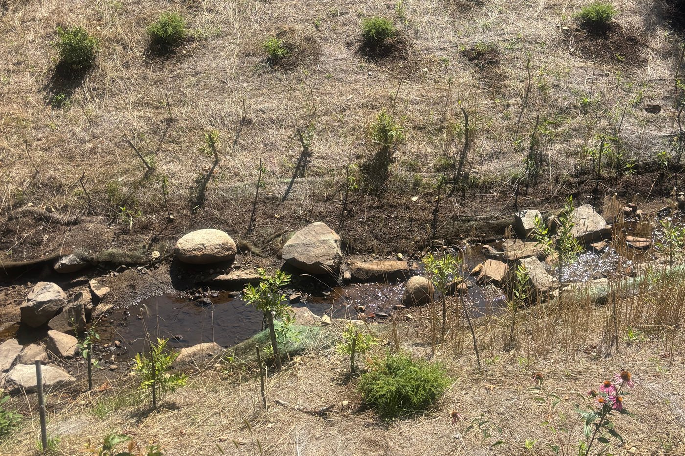
Working with the Cumberland County Soil and Water Conservation District’s engineer Chris Baldwin, the Portland Water District and state transportation department excavated the granite culvert to create a natural ravine with sloping sides for the brook to flow through. The initial phase of the project cost $120,000.
To stabilize the sides of the ravine, the water district worked with Paul Larrivee, a local forester, to plant native vegetation, including juniper, sweet fern and purple coneflower. They also used live-staking with dogwood and pussy willow, and put down temporary erosion-control mats and blankets — rolled materials made from natural fibers designed to stabilize bare soil and protect newly seeded areas from rain and wind. Purchasing, planting and maintaining the vegetation cost around $30,000, which was paid for by the water district.
The planting was done in June, ideally giving the vegetation enough time to grow and stabilize before the winter months. The forester comes out and monitors the plants and live stacks once or twice a week, providing extra watering during dry spells.
“With this project, there’s a lot of initial work to make sure the plants survive and grow, but hopefully, once they’re established, we won’t have to do much maintenance,” Thompson said. If successful, the Standish Brook project will stabilize the ravine, prevent further flooding in the area and help keep invasive plant species at bay.
Nature-based solutions, said state officials, are dynamic and complex, and if they are going to serve as long-term solutions, they require continual monitoring and care.
“One of the unique things about this kind of work is you can’t just say at the end of the project, ‘That worked,’” said John Maclaine of the DEP, who assists with O.U.R. S.H.O.R.E. “Living things take time and get stronger over time. Part of this is continually going back to look at what you’ve done.”
___
This story was originally published by The Maine Monitor and distributed through a partnership with The Associated Press.
News from © The Associated Press, . All rights reserved.
This material may not be published, broadcast, rewritten or redistributed.

This site is protected by reCAPTCHA and the Google Privacy Policy and Terms of Service apply.
Want to share your thoughts, add context, or connect with others in your community?
You must be logged in to post a comment.