Elevate your local knowledge
Sign up for the iNFOnews newsletter today!

The Okanagan’s water shortage is hitting the Vernon area hardest for now, but the region is seeing historic lows this year with little precipitation in sight.
Drastic reductions for some North Okanagan farmers have already used up their allotment this month, but a BC cabinet minister is asking Okanagan residents to drastically cutback on their water use.
“You’re seeing more municipalities increase their water restrictions… Some parts of the province are experiencing very low stream flows, especially in the Okanagan, where we’re actually seeing record lows,” Water, Land and Resource Stewardship Minister Randene Neill said at a recent news conference.
She pointed to two waterways, Bessette Creek and Salmon River, which lead to Shuswap Lake are particularly low. There are plenty more throughout the Okanagan that are at their lowest recorded levels, like Mission and Vernon creeks, with warm temperatures threatening fish habitats, according to the BC River Forecast Centre.
Some of the large lakes those streams flow into are low, including Okanagan and Kalamalka.
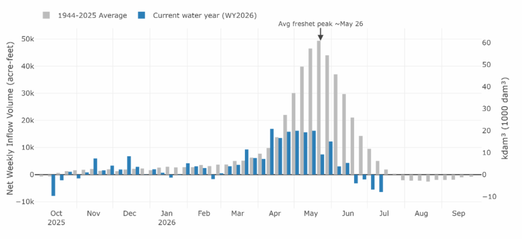
Last month, Okanagan Lake was losing more water than was coming in and, on July 1, reached its lowest point on that date since 1992, according to the Okanagan Basin Water Board.
While farmers in the North Okanagan decried restrictions that left those in the Vernon area with a 70 per cent reduction in their water allotments, a regional district staffer said the shortage, particularly in the Duteau reservoirs, is worse than ever.
“This is definitely uncharted territory. Looking back on the history of Duteau reservoirs, they fill just about every year, and if they don’t it’s so close to the top and spilling,” North Okanagan Regional District water efficiency coordinator, Amanda Summerfelt, said.
When snowpack is low, the region typically counts on precipitation to top-up what’s needed. That hasn’t happened.
“It’s really challenging in the early season to predict where we ended up this year,” she said.
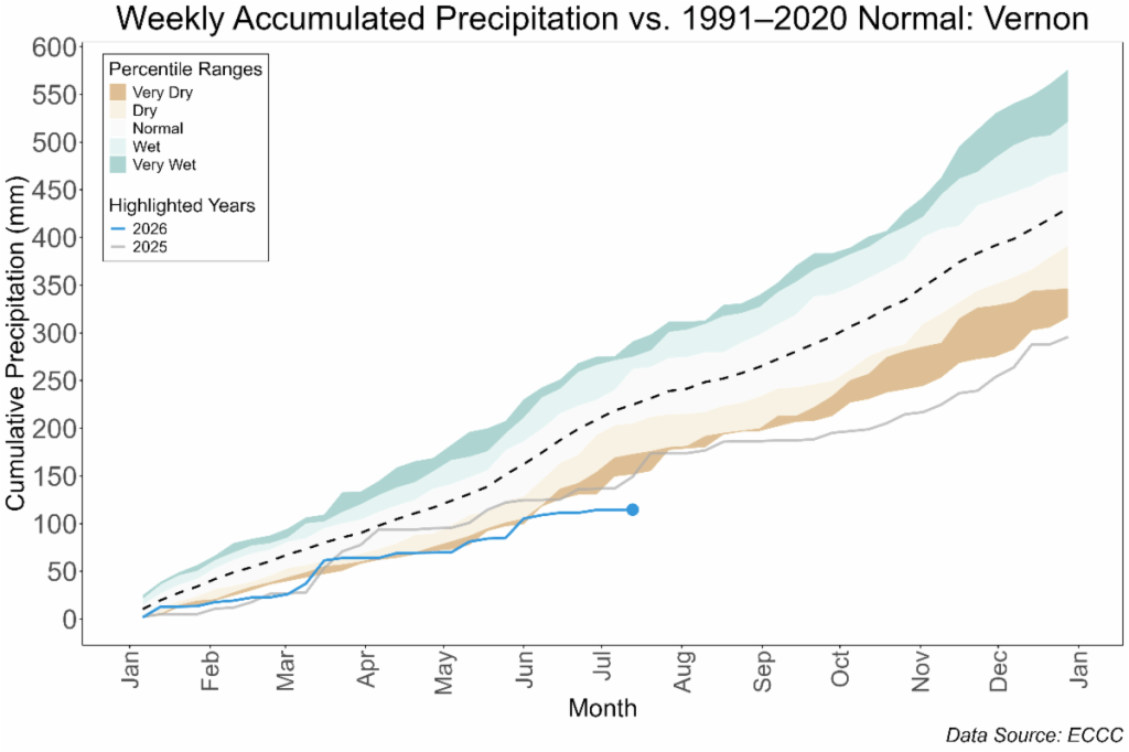
According to data compiled by the Okanagan water board, the Vernon area gets nearly 200 millimetres of precipitation from January to mid-July. That’s the average accumulated through that time.
This year, it’s far below average and nearly plateaued at the end of May with around half that total.
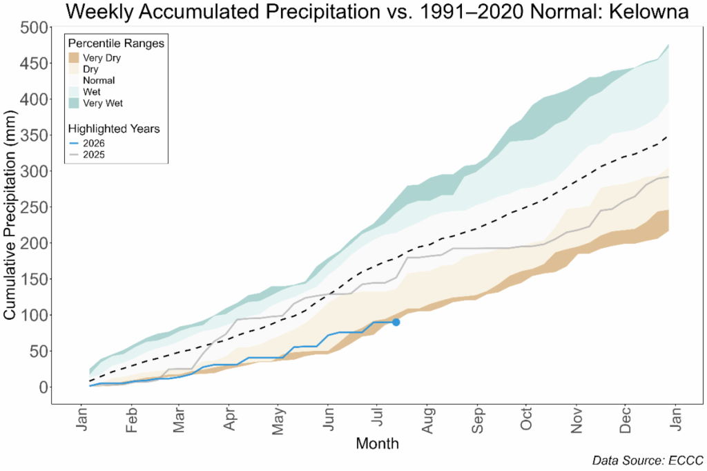
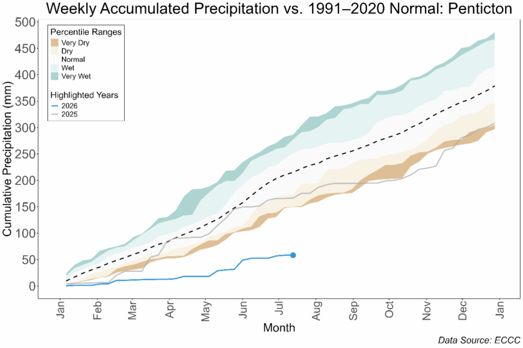
The Kelowna area is more varied, but it sees an average of around 150 mm by mid-July. It’s at less than 100 mm in 2026 so far. Penticton, meanwhile, has had closer to an accumulated 50 mm of precipitation compared to its 200 mm average, which would typically climb with rains in June.
Much of the Okanagan is under varying water restrictions, while Kamloops recently stepped up to its level four drought response. Like West Kelowna, it means lawns can only be watered once per week.
Though Thompson River levels have not dropped to historic lows, measurements taken in Chase and Savona show water levels peaked in June, a month earlier than normal. Up until then, flow levels were close to average, but they are falling quickly as the area sees little rain.
Go here for more information on water restrictions in the Okanagan and here for Kamloops.
News from © iNFOnews.ca, . All rights reserved.
This material may not be published, broadcast, rewritten or redistributed.

This site is protected by reCAPTCHA and the Google Privacy Policy and Terms of Service apply.
Want to share your thoughts, add context, or connect with others in your community?
You must be logged in to post a comment.